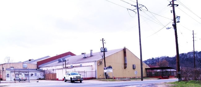
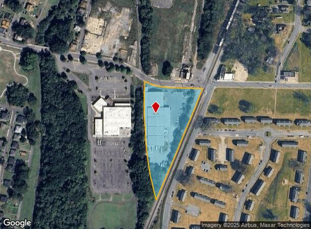
Property Record
20 E 12Th St Sw, Rome, GA 30161

NEARBY LISTINGS FOR SALE OR LEASE
Property Detail
20 E 12Th St Sw
J14K-001
LL284 285 316 317 23/3 PB 16-255
Warehouse
Floyd
X
Georgia
13115C0281F
3.30 AC
2025
Georgia Northwest
2024
Other Market Areas
001600
Rome, GA
38,600 SF
DEMOGRAPHICS near 20 E 12Th St Sw
1 Mile
3 Mile
5 Mile
2024 Total Population
6,815
29,817
58,337
2029 Population
7,114
30,798
59,857
Pop Growth 2024-2029
+ 4.39%
+ 3.29%
+ 2.61%
Average Age
38
39
38
2024 Total Households
2,697
11,679
21,474
HH Growth 2024-2029
+ 4.41%
+ 3.42%
+ 2.75%
Median Household Inc
$37,629
$47,882
$53,566
Avg Household Size
2.40
2.40
2.50
2024 Avg HH Vehicles
1.00
2.00
2.00
Median Home Value
$143,521
$209,919
$183,401
Median Year Built
1961
1970
1972
Nearby Places
Map Layers
Map Styles
 Street
 Aerial
- Restaurants
- Banks
- Shops
- Fitness
- Groceries
SALE & LEASE HISTORY
LISTING DATE
SALE/LEASE

Sep 25, 2016
For Lease
Sep 24, 2016
For Sale
Nov 22, 2016
For Lease
Jan 03, 2018
For Sale
Nearby Properties
Address
Land Use
TOTAL SIZE
Lot Size
Zoning
Address
Land Use
TOTAL SIZE
Lot Size
Zoning
18.34 AC
O-I
Address
Land Use
TOTAL SIZE
Lot Size
Zoning
62,832 SF
H-I
Address
Land Use
TOTAL SIZE
Lot Size
Zoning
108,547 SF
1.54 AC
U-M-U
Address
Land Use
TOTAL SIZE
Lot Size
Zoning
203,082 SF
22.05 AC
H-I
Address
Land Use
TOTAL SIZE
Lot Size
Zoning
20,532 SF
16.56 AC
C-C
Address
Land Use
TOTAL SIZE
Lot Size
Zoning
30,991 SF
8.94 AC
Address
Land Use
TOTAL SIZE
Lot Size
Zoning
141,680 SF
6.27 AC
U-M-U
Address
Land Use
TOTAL SIZE
Lot Size
Zoning
1,980 SF
40.80 AC
H-I
Address
Land Use
TOTAL SIZE
Lot Size
Zoning
54,817 SF
8.82 AC
C-C
Address
Land Use
TOTAL SIZE
Lot Size
Zoning
83,971 SF
0.29 AC
Address
Land Use
TOTAL SIZE
Lot Size
Zoning
3,416 SF
13.87 AC
C-C
Address
Land Use
TOTAL SIZE
Lot Size
Zoning
52,321 SF
Address
Land Use
TOTAL SIZE
Lot Size
Zoning
17,904 SF
14.19 AC
H-I
Address
Land Use
TOTAL SIZE
Lot Size
Zoning
137,726 SF
12.51 AC
C-C
Address
Land Use
TOTAL SIZE
Lot Size
Zoning
59,796 SF
Address
Land Use
TOTAL SIZE
Lot Size
Zoning
59,082 SF
8 AC
C-C
Address
Land Use
TOTAL SIZE
Lot Size
Zoning
19.64 AC
Address
Land Use
TOTAL SIZE
Lot Size
Zoning
89,250 SF
7.05 AC
C-C
Address
Land Use
TOTAL SIZE
Lot Size
Zoning
42,440 SF
4.30 AC
C-C
Address
Land Use
TOTAL SIZE
Lot Size
Zoning
6,998 SF
15 AC
M-R
Address
Land Use
TOTAL SIZE
Lot Size
Zoning
184,996 SF
25.90 AC
C-C
Address
Land Use
TOTAL SIZE
Lot Size
Zoning
26.30 AC
H-I
Address
Land Use
TOTAL SIZE
Lot Size
Zoning
11.84 AC
Address
Land Use
TOTAL SIZE
Lot Size
Zoning
61,577 SF
1.31 AC
C-C
Address
Land Use
TOTAL SIZE
Lot Size
Zoning
6.35 AC
M-R
Address
Land Use
TOTAL SIZE
Lot Size
Zoning
2.62 AC
C-B-C
Address
Land Use
TOTAL SIZE
Lot Size
Zoning
130.40 AC
O-I
Address
Land Use
TOTAL SIZE
Lot Size
Zoning
38,070 SF
0.83 AC
C-C
Address
Land Use
TOTAL SIZE
Lot Size
Zoning
82,962 SF
4 AC
N-O-C
Address
Land Use
TOTAL SIZE
Lot Size
Zoning
101,860 SF
11.80 AC
C-C
The World's #1 Commercial Real Estate Marketplace
Connect with us
© 2025 CoStar Group
The information above has been obtained from sources believed reliable. While we do not doubt its accuracy we have not verified it and make no guarantee, warranty or representation about it. It is your responsibility to independently confirm its accuracy and completeness. Any projections, opinions, assumptions, or estimates used are for example only and do not represent the current or future performance of the property. The value of this transaction to you depends on tax and other factors which should be evaluated by your tax, financial, and legal advisors. You and your advisors should conduct a careful, independent investigation of the property to determine to your satisfaction the suitability of the property for your needs.